🏆 Ranked: Hardest Hikes in Joshua Tree
1. Quail Mountain (5,816 ft)
- Distance: 12–14 miles RT (off-trail)
- Why it’s the hardest: Highest peak in Joshua Tree, no official trail, requires navigation skills, long distance, and high elevation gain.
- For: Experienced hikers, strong navigation skills, backcountry readiness.
2. Boy Scout Trail (with Willow Hole spur or shuttle setup)
- Distance: 8–12+ miles
- Why it’s tough: Long, exposed, can be very hot, and logistics (shuttle or out-and-back) add difficulty.
- For: Fit hikers comfortable with long days in desert conditions.
3. Lost Palms Oasis
- Distance: 7.5 miles RT
- Why it’s tough: Remote desert canyon, sandy sections, strenuous return climb from the oasis.
- For: Hikers wanting a strenuous but marked trail to a unique palm oasis.
4. Warren Peak
- Distance: 6.3 miles RT
- Why it’s tough: Sustained climb, sandy trail makes footing harder, sun exposure.
- For: Peak-baggers wanting sweeping views without going off-trail.
5. Ryan Mountain
- Distance: 3 miles RT
- Why it’s tough: Short but steep (~1,050 ft elevation gain in 1.5 miles).
- For: Anyone who wants a hard, high-reward hike with panoramic summit views.
6. Fortynine Palms Oasis
- Distance: 3 miles RT
- Why it’s tough: Moderate length but steep up-and-over route with sun exposure both ways.
- For: Those who want a shorter but still challenging trek to a shady oasis.
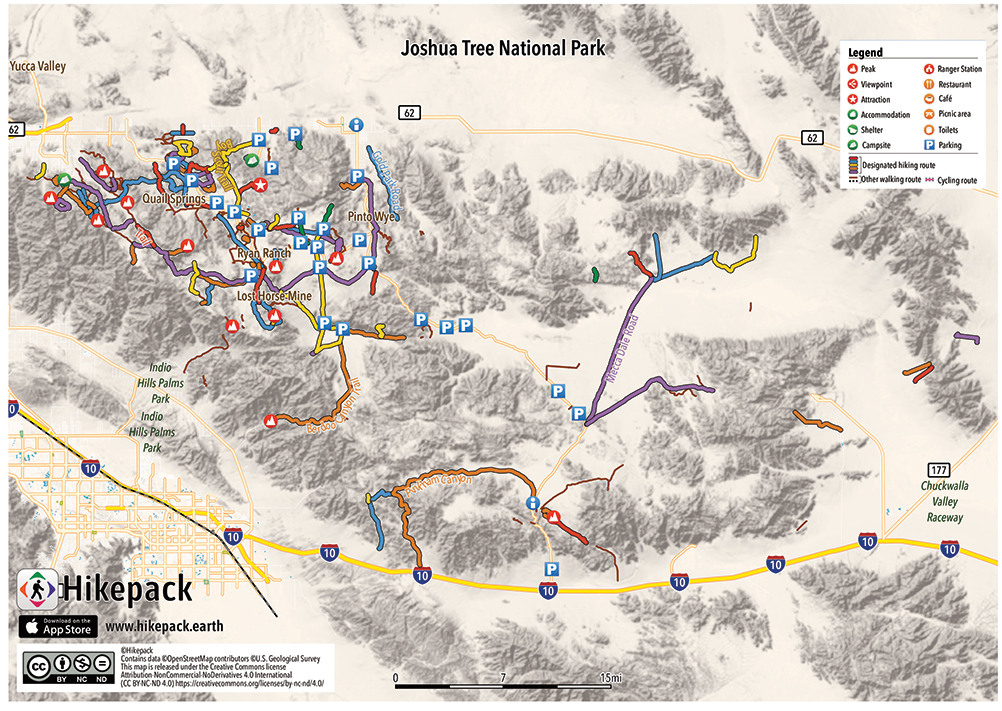
🗺️ Location Overview
- Northwest (near Joshua Tree town):
- Ryan Mountain
- Boy Scout Trail (runs NW to Indian Cove)
- West (Black Rock Canyon area):
- Warren Peak
- Central:
- Quail Mountain (backcountry route)
- North-Central (near 29 Palms):
- Fortynine Palms Oasis
- South (near Cottonwood Visitor Center):
- Lost Palms Oasis
⚠️ Tips for Difficult Hikes in Joshua Tree
- Always carry plenty of water (at least 3–4 liters per person, more for long hikes).
- Start early in the morning to avoid extreme heat.
- Bring a hat, sunscreen, and layers (can be hot in day, cold at night).
- Use a GPS app or map—trails can be faint and desert terrain is disorienting.
- Cell service is unreliable.
| Rank | Trail / Peak | Area on Map | Difficulty Highlights |
|---|---|---|---|
| 1 | Quail Mountain | Central-southern region, off-trail | Unmarked route, highest summit (~5,816 ft), major navigation required |
| 2 | Boy Scout Trail | Northwest quadrant | Long distance, exposed terrain, logistical considerations |
| 3 | Lost Palms Oasis Trail | South region near Cottonwood Spring | Rugged terrain, sandy, strenuous climb and descent |
| 4 | Warren Peak | West — Black Rock Canyon area | Sandy, steep summit approach with solid elevation gain |
| 5 | Ryan Mountain | Central-west, near main park road | Steep 1,050 ft gain over ~1.5 mi one way Wikipedia |
| 6 | Fortynine Palms Oasis Trail | North-central (close to Hwy 62) | Ridge climb to shaded oasis, 300 ft elevation each way Wikipedia |
Make sure to take lot of water and food with you before trying any Hikes in Joshua Tree.
Tags: hikes in Joshua tree, joshua tree national park hikes, joshua tree national park trails, joshua tree trails, trails in joshua tree